
INTRODUCTION AND DESCRIPTION OF STUDY BELOW
The information below discusses the “state of the Atmosphere with respect to prospects for the early hurricane season. As you know, many meteorologists have called for a very inactive season, partly due to lower than average TCHP (see info below) and the onset of El Nino. However, some criteria such as a return to a slightly positiveAMO in the Atlantic (warmer ocean temps), expected lower wind shear and the fact in our minds, El Nino has yet to form, could possibly spark a bit more interest in the hurricane season, especially if El Nino development is delayed.
There is a new phenomenon called El Nino Modoki (not discussed here), in which certain El Ninos forms when the warmest SST’s and hence shear, are further west in the Pacific.This can actually prevent the normal supression of the hurricane season to exist and something that needs to be watched.
Overall, however, we are not changing our earlier forecasts for a mostly inactiveseason, but below is interesting reading nevertheless.
WHAT USUALLY HAPPENS IN LATE JULY?
Atlantic tropical/hurricane activity usually begins picking up by now. Since the active hurricane phase since the mid 1990’s, brought on in part by mostly a warmer positive phase of the AMO (Atlantic SST’s), there have been 7 hurricanes in the last 14 years, in which we had a named storm in the Atlantic before July 15th. Hurricane Dennis and Emily were the strongest ever so early in the season, with both occurring of course in July 2005. Last year, we had one very rare July hurricane that actually formed just off the Cape VerdeIslands.
Most hurricane this time of the year occur near the Gulf of Mexico, Western Caribbean or waters off North Carolina, but as we get later in the season, the majority will come as tropical waves off the west coast of Africa (see pic insert of tropical waves). Nearly 85% of all hurricanes that have created major market moves in natural gas/and/or crude occurred from waves of the Cape VerdeIslands, that we call “long track hurricanes.”
For now, models that may suggest any strong waves coming off the coast of Africa as potential hurricanes should probably not be believed, especially if the GFS is the lone model showing something. When we get in August and September, however, this is the more likely breeding ground.
Neverthess, something could form in the central or western Atlantic next week, and believe it or not, was a major reason OJ futures rallied the last couple days and is probably way overdone.
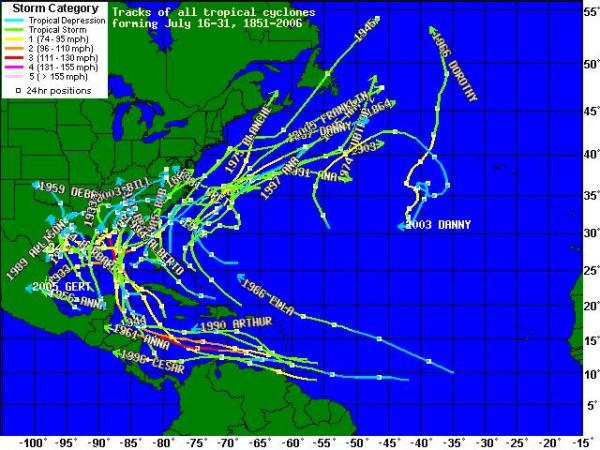
HISTORY OF HURRICANE TRACKS THE LAST 2 WEEKS OF JULY
(2007 AND 2008 NOT INCLUDED)
AZORES HIGH AND NAO INDEX
The position of the Azores High has a big influence in summer and fall hurricane tracks. In part 2 of a discussion within the next week or so, we will talk more about this high and how the NAO and other teleconnections influence it and hurricane tracks.
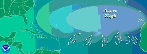
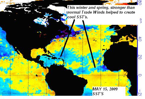
Currently, we are seeing about normalSST’s in the tropical Atlantic between Africa. The recent negative phase of the NAO index has likely weakened the AzoresHigh somewhat or visa-versa, helping to weaken theTrade Winds and warm thetropical Atlantic Stronger than average Trade Winds around the Azores high this winter and spring frommostly a +NAO indexinitially helped cool the tropical Atlantic quite a bit. What happened was, that strong winds brought up colder waters from beneath the surface of the ocean. SST’s are expected to remain about average over the next couple weeks. The NAO index is quite important in determining Atlantic SST’s and will play an important role in the hurricane season later this summer and fall.
SST’S IN MAY
Notice the cooler than normal waters in the Atlantic and off the coast of W. Africa, brought on, in part, by a stronger Azores High and +NAO
PRESENT SST’S

Tropical Cyclone Heat Potential
Daily Oceanic Heat Content or Tropical Cyclone Heat Potential (TCHP) estimates are provided by Gustavo Goni at the Physical Oceanography Division of the NOAA Atlantic Oceanographic and Meteorological Laboratory located in Miami, FL. The spatial grid spacing is 0.2 Latitude x 0.2 Longitude and the units of the estimates are given as kJ/cm^2. A detailed description of how the product is created, product archives and TCHP in other regions can be found at Gustavo’s web discussing TCHP. Tropical cyclone forecasts, as described above, are plotted on values of ocean heat content for reference.
For tropical cyclones in favorable environmental conditions for intensification (i.e., vertical wind shear less than 15 kt, mid-level relative humidity >50 %, and warm SSTs [i.e., >28.5C])and with intensities less than 80kt, values of ocean heat content greater than 50 kJ/cm^2 have been shown to promote greater rates of intensity change.
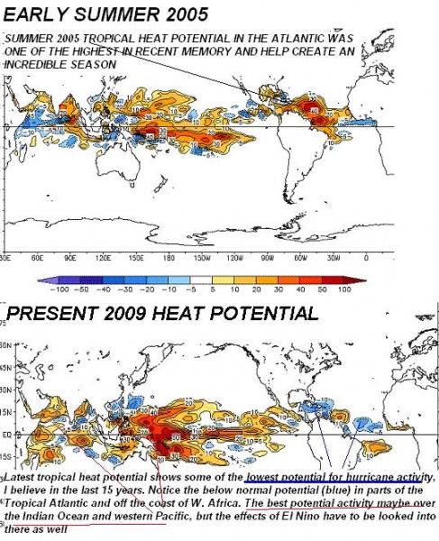
THE AMO HAS GONE SLIGHTLY POSITIVE AND ATLANTIC SST’S HAVE WARMED TO NORMAL. SO DOES THIS INCREASE THE CHANCES OFA MORE ACTIVE SEASON?
It is not just the SST’s that are important for hurricanes, but its also about the “total amount of heat” in the ocean to a depth of 150 meters. Since hurricanes stir up water from deep down due to their high winds, a shallow warm layer is not as beneficial to development as a deep one.
Hence, the fact that some warming has certainly occurred in the Atlantic of late, does not necessarily project an active season.
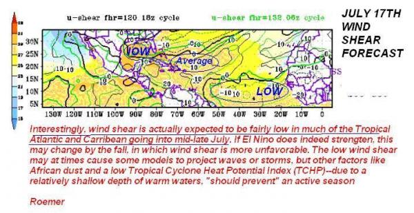
In addition, wind shear needs to be below 15 Knots and mid-level relative humidity of greater than 50% to insure adequate development. Thus far, greater than normal wind shear and above normal African Dust have cut down on any chances for an active hurricane season.
DUST
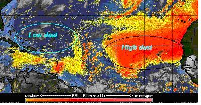
African dust can increase local vertical wind shear in the N. Atlantic. This is different than horizontal wind shear (described above), which will actually be fairly light and may possibly be favorable for tropical development later in July (but again, other ingredients are not favorable).
Some tropical cyclonesthat areweakened by Saharan Dust,can actually emergelater away from the dust and see rapid intensification.
CURRENT DUST CONDITIONS
I show this graphic below because any model (such as the GFS) that may show, at times, a tropical storm or hurricane developing off the west coast of Africa, north of 15 Nwill be wrong, for now.
Part of the reason is climatology and part of the reason–too much dust north of 15 N.
However, With low wind shear expected (map above) and limited dust levels in the eastern Carribean and western Atlantic, some modelshave begun showing the potential for a depression or tropicalstorm in the central Carribean in about a week.
EL NINO WHY DOES IT SUPRESS HURRICANES
NOAA officially stated on July 10th that El Nino has formed, since region 3.4 in the equatorial Pacific has now risen to risen above +0.5 Oc for greater than 3 months. However When El Nino forms, the pattern of surface wind, upper level wind and Sea Surface Temps usually result in greater wind shear in the tropical Atlantic. However, as stated above, wind shear is actually forecasted to be lighter than normal in many areas. Though we still expect El Nino conditions to form, right now, the atmosphere is not necessarily completely in an El Ninostage. For one thing, the SOI index has been positive during most of the last 3 weeks! While the potential is certainly there for El Nino, the 30 day SOI index has actually gone positive. This might”possibly suggest” that the expected wind shear, etc. in the Atlantic, associated with El Nino will not be as great, later in the season as some suggest. Though we want to be consistent in our thinking that this season will be in active. I just wanted to point this out that a more positive SOI index and lack of really strong shear in the Atlantic may “possibly suggest a couple surprises later this summer or fall.
The natural gas market is factoring in a cool summer and lack of hurricane season right now, so any sudden change might result in aggressive short covering, but for now, we see nothing from a weather standpoint, to get excited about.
-Roemer